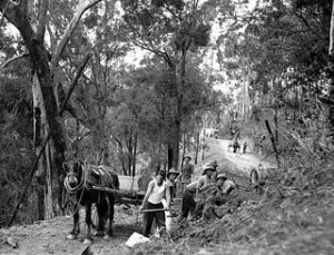
Roads during the convict period
The only stretch of ‘made’ road during the convict era was roughly a mile long on the river embankment to the government’s wharf. The rest were simple cattle or dray tracks both in town as well as to the outer stations.
As there was ongoing uncertainty about the future of the settlement, no investment were made in any infrastructure. It wasn’t until Commander Cotton in 1837 finally decided that there was a future for the settlement and that preparations were needed to make that happen. Among his initiative was a plan for proper land-links. He suggested that the river links were not enough for the proper development of a permanent settlement. He plan suggested was based on a spokes of the wheel design, with Brisbane as its centre. He even marked the roads to the outer settlements with a plough. However, his plans were blocked by the British government who still wanted to permanently close the settlement.
Even after the settlement was opened to free settlers, the government did not spend any money on infrastructure. This was mostly left to the settlers. Occasionally the government participated with some money towards the bridges that needed to be built over the numerous creeks traversing the settlement.
During the 1839 survey on paper at least the streets in town were designed by surveyor Robert Dixon. They were planned to link the various buildings and activities within the town centre. The convict barracks to the military quarter and the administrative centre. The road to the windmill and to the government garden (agriculture gardens now Botanic Garden). Governor Gibbs ordered Wade to narrow the road to 66 feet (19.8 meters) as Brisbane to would never be moire than a paltry village. Surveyor Henry Wade supported by Andrew Petrie widened it to 80 feet (24 meters). The street names were chosen from British Royalty.
It was not until 1851 before the streets footpath were being outlined along the tracks in town, they were marked by iron-bark posts. The following year for the first time government money (£153) was allocated for street repairs.
In the 1840s the road to the Female Factory (Goal Hill) and from here to the agriculture area beyond Breakfast Creek and via what is now Hamilton Drive to the new Female Factory, was surveyed.
All of these roads were still only tracks and were nearly impassable when it rained, let alone when the river flooded the flats along the Brisbane River and when the many creeks overflowed.
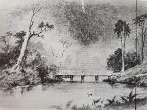
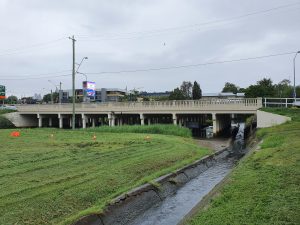
The first bridges over the creeks were simply made from wooden logs which often washed away during floods and or collapsed because of lack of maintenance. The first of such bridges dated from the convict era and were over Wheat Creek on the track from the convict barracks to the windmill, roughly where Albert and Adelaide Streets intersect. Two more appeared over this creek further towards Creek Street and one where the creek ended in the Brisbane River.
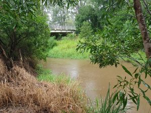
The bridge over Breakfast Creek was the next to be build, most likely most of the work here was done by the female convicts as this bridge and track was needed to connect their prison at Eagle Farm to the main settlement. By 1849 the bridge was mostly washed away. For years the Government refused to come to the party and the residents of the northern districts had to fix the crossing here themselves. A year later £100 pound was provided and the other £80 was again provided by the residents. The bridge was essential as it was on the most direct road to the bay. More money was needed a few years later but no funds were made available.
In the 1850s also the first road to Fortitude Valley was surveyed and a road was build over a swamp at Newstead.
Traversing the Great Divide
During the convict period in the 1820s, several explorers were active in the area north of Brisbane. The botanist Allan Cunningham had arrived travelling overland from Sydney. Commander Patrick Logan travelled towards the Great Divide from Brisbane. They both took place in subsequent expeditions. Squatters started to arrive in the Darling Downs and the valleys of the northern parts of the Brisbane River, the Lockyer and the Fessifern. In order to traverse the various ranges, they established the Cunningham Gap, Spicer Gap and Hodgson Gap. All rather treacherous tracks over the mountains. These early explorations are described in more detail here.
In 1851, £2,175 (£25 per mile) was made available for improvements to the road from Brisbane, via Ipwsich through the gap to Drayton. Another £315 of funding was provided for the Ipswich – Spicer’s Gap road.
River crossings
The crossing over Brisbane River was outsourced to private enterprise and the first ferry for people, horses and carriages started to operate in 1842 (until that time the crossing was done by rowing boat, now replaced by a punt).
This private ferry linked the North and South Brisbane. The second ferry crossing between North Brisbane (Edward Street) and Kangaroo Point was leased to a private contractor two years later. A road from this ferry (Main Road) led straight to Ipswich Road and provided the wharves in Kangaroo Point (like South Brisbane) with direct access to the Darling Downs, at this stage that road was not much more than a dray track.
The more industrial site of Kangaroo Point now started to compete with South Brisbane as the major port for produce coming from the Darling Downs. A 3rd ferry between Customs House and Kangaroo Point was established in 1844. Floods created havoc to the ferries and its approaches and £700 was made available for improvements, a new more efficient punt with waterwheels was also being built by Andrew Petrie.
The western end of Turbot street abutting the Brisbane River also had ferry steps, towards the then-Stanley Street, South Brisbane.The ferry point was closed in May 1875, and within a year the old shed was harbouring ‘idle and disorderly people.
It was not for that long before the ferry landing spots became inaccessible. It required proper access points and roads to and from the ferries. Ferry traffic rapidly increased and that only made the situation worse. The price of the annual ferry leases went through the roof but the government failed to use that money to properly fund the work needed to improve the situation. Some work was done in 1847, but two years later that proofed not be enough and further improvements were made two years later. However the situation was never properly addressed and remained a situation of filling potholes and repairing existing timbers.
For all the roads in Moreton Bay a meager found of £200 was made available in 1849. The repairs for the ferry approaches alone was already £85. Most of the repairs was still largely left to private initiatives.
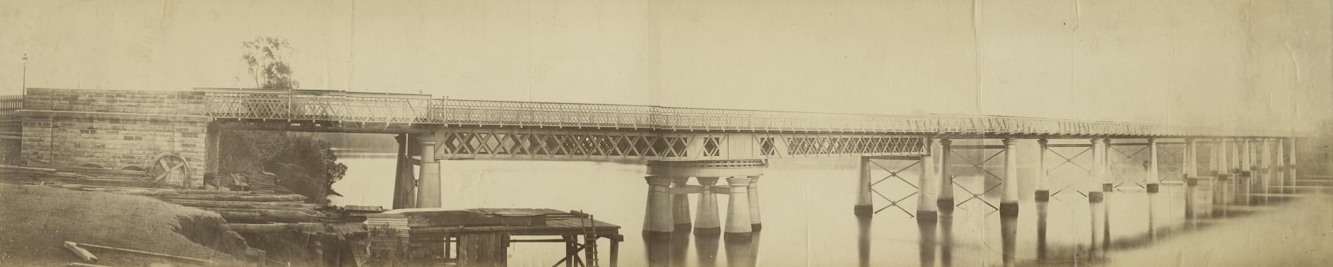
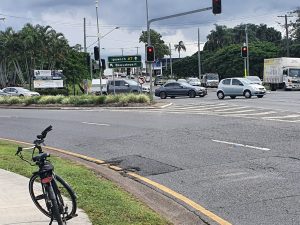
It was until 1865 that the first bridge over Brisbane River was built between North and South Brisbane (Victoria Bridge). However, it collapsed a few years later and a new one was built in 1874.
The convict road from Brisbane to Ipswich
The major way of transport was by river, as South Bank provided the easiest access to the river for transport purposes it was here that the first primitive wharf was built, basically logs placed next to the riverbank. Here they were tied to the ‘famous’ Macintyre Gum Tree. After a dispute with the owner, the Hunter River Steam Navigation Company built, in 1845, close to that spot a river wharf and stores.
Rather rapidly outlaying stations were established Limestone (later Ipswich) and Emu Point (Cleveland) earmarked as a port. Cattle stations appeared at Red Bank (Redbank) and Logan.
River transport was not an option for the transport of sheep and cattle and thus tracks started to appear linking the penal settlement to the outlaying stations all the way to Limestone. As these animals need water the track went from waterhole to waterholes and followed creeks. It winded its way to fords allowing the animals to cross creeks . Most likely it used existing Aboriginal tracks where possible. Under ‘normal circumstances’ roads would be developed using ridges. However from the settlement it followed swaps and Norman Creek and only joined the rise at what is now the Chardons Corner end of Annerley.
Two main tracks developed one from Cleveland and one from Brisbane both to Limestone, they intersected at Cowper’s Plains (Coopers Plains).
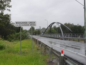
In 1839, Robert Dixon surveyed a road to Coopers Plain and Eagle Farm. Surveyor Granville Stapylton was the first one to survey a road from Brisbane to Ipswich following the old convict dray track for most of its course. He also looked at the crossings of the Oxley, Woogaroo and Bundamba creeks. Staplyton was killed by Aboriginals when surveying a road to the Richmond river near Mt Lindesay.
In 1851 money was allocated to build bridges over the Oxley and Woogaroo Creeks. At the same time funding was provided for improvements to the road from the Darling Downs via Coopers Plains to Cleveland. In 1854 a call went out for 20 to 30 labourers to work on improving the road from Brisbane to the Downs.
Since Separation in 1859 the border between Brisbane and Ipswich has been the Woogaroo Creek.
As the convict-built tracks were of a poor quality there is nothing left of it. Mark Baker in a paper: A twisted tale: the many roads to Ipswich (published in volume 24, No .8 Feb 2021 in the newsletter of the Royal Historical Society of Queensland) traced – based on a map from surveyor Granville Stapyltonfrom 1839 – the original 41 km convict build track to Ipswich.
From the south bank of the river at Brisbane Town, the track followed a chain of waterholes: One Mile Swamp (Woolloongabba), Burnett’s Swamp (Stones Corner), and Four Mile Swamp (Moorooka). It proceeded south crossing Rocky Water Holes Creek and Stable Swamp Creek to reach Cowper’s Plains where the Limestone track branched to the south-west. From here it crossed Canoe (Oxley) Creek and skirted Blunder Creek and McGuire’s Blunder (waterholes), proceeding over a ridgeline to cross Bullock Head Creek and Wolston Creek before fording Woogaroo Creek about three km upstream from its confluence with the Brisbane River. Here the overland road met the major thoroughfare the Brisbane River. To the west was the Red Bank outstation (Redbank) on Goodna Creek. From here, Six Mile Creek was crossed before ascending the Iron Bark Ridges from where it descended to cross Bundamba Creek and then headed west to reach Limestone (Ipswich).
After the penal settlement was closed and free settlement was allowed the areas along the river and the convict road rapidly developed. While, with the arrival of steam ships, river transport received a significant boost, it was expensive in relation to overland transport and in particular for sheep and cattle transport. So the convict road equally saw a significant increase in traffic. As the road was never properly built it was permanently in a state of disrepair. It developed into a range of tracks , one bypassing the other impassible stretch. A good example is the situation in Goodna in a plan dated 1856 it shows four crossings of the Woogaroo creek; a ford for drays, a footbridge, an old bridge on the Ipswich Road and a new proposed bridge on what a year later became the new route of the Ipswich Road, bypassing bits of the old road.
In 1844, because of a lack of Government action, the squatters formed the Moreton Bay District Association and put some money on the table to fix some of the worse parts. It was decided to bypass the swamps at McGuire Blunder, but required a bridge over Canoe Creek at Oxley, about 2 kilometres above the crossing at the swamps. The costs were estimated at £40, Police Magistrate Wickham organised convicts to do the work and Commissioner for Crown Land Dr Stephen Simpson provided the logs. This also allowed travelers to bypass much of the swampy grounds near the creek.
I have used that map and Mark’s information to try and trace the old convict road. In tracing the road, I am using a few speculative clues such as the indication that it followed waterholes, the fact that often old tracks are transformed into roads. As the track followed the river, creeks and waterholes, there was never one track rather several of them depending on which one could be used at the time. Most certainly certain parts of this road would follow existing track used by the local Aboriginal people.
However, as the track was unsuitable for coaches a new road to Ipswich was surveyed and build between 1860 and 1864. Parts of the convict track were incorporated in this road.
With the increase of new settlers new areas were occupied by housing and to access the new plots new tracks were established. One of the more important ones was Boggo Track, a more direct road that the convict track in this area a bit further to the east.
As mentioned, all these tracks started in South Bank, here the ferry departing from the wharf at the Commissariat Store in North Brisbane crossed the river and arrived at what is now Russel Street. You can still follow this street where it ends at the river.
Bob Eason recalls the following in 2006, in the book World War II Stories from Brisbane South West, written by Vicki Mynott.
“Ipswich Road was also part of the stock route from the Darling Downes to Brisbane. The stock road was as old as the road I reckon. We would hear the whips cracking and the dogs barking, and all the kids would rush up to see the mob of cattle and sheep pass – en route to Foggett Jones Hutton (who had holdings yards at Oxley) and/or to Cannon Hill saleyards. But I didn’t see these droving mobs after 1932-1933.
Ipswich Road was a single lane then, with deep gutters on either side and only the occasional car, The Wacol-Oxley stretch was the last to be bituminised, about 1926 – and the families of two men who worked on it lived in tents on the Darra Recreation Ground”.
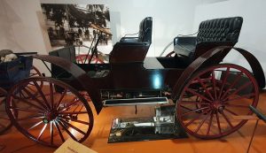
This auto buggy is a real `horseless carriage’, designed to appeal to farmers who were used to horse-drawn vehicles. It was made in 1909 (just a year before the FN 1560 motor car) by the International Harvester Company of Ohio, USA, well-known manufacturers of agricultural equipment. This auto buggy was bought second-hand in 1914 by Mr T. Jackson, who used it as a taxi between Nudgee Railway Station and Cribb Island in Brisbane. It has been repaired several times and was presented to the Royal Historical Society of Queensland in 1940.
Tracing the Road – Starting from South Bank
Here the track was followed most likely the river, as the land was flat and easy to traverse. Once wharves got build the road moved further land inwards so there is nothing left of the original track here. Perhaps the only clue is the position of the Shipp Inn. Part of the original road could possible still have been here when this inn was built in 1864, if that is the case it would have followed the bend in the river following what now is Stanley Street.
Woolloongabba (then known as One Mile Swamp)
Before it reached what was known as One Mile Swamp it turned east. A bypass of the convict track was built in the 1850s starting at what now is Clarence Corner through the Boggo Scrub (see later). However, the old track turned east pas Clarence Corner.
One Mile Swamp which was roughly situated between what is now Vulture and Stanley Streets, and Wellington and Merton Roads. There was still a drays camp in 1840s and 1850s. The Gabba is built on part of the old swamp.
Perhaps a small part of this part of the track is now incorporated in Ipswich Road. Once that road was built – in the 1860s – it bypassed the old track along Burnett’s Swamp.
At what is now Stones Corner the old track turned south skirting Burnett’s Swamp along the Norman Creek.
Stones Corner (Burnett’s Swamp)
It most likely followed the first part of the narrow Slacks walking track and skirted the swamp on the eastern side.
Slacks Track developed later (Logan Road) was an Aboriginal pathway and was later on used by the Slack family to drive their livestock to the Brisbane market from the Albert and Logan River settlements. The current Logan Motorway largely follows the old trajectory.
Much later, in 1875, James Stones bought the triangle of land here (the corner) and opened a hotel in 1888. Brenda Koster, a distant family member is under the impression that James Stone was unsuccessful in getting a liquor licence. This resulted in his brand of non alcoholic ginger beer is still in production.
From here also the Old Cleveland Road starts. This was the track from Brisbane to Cleveland. The road from Limestone (Ipswich) to Cleveland used by the squatters (Squatters Highway) was further south and crossed the convict road at Cowpers Plains (see later). The squatters preferred a port at Cleveland rather than at Brisbane.
Not sure where the name Burnett’s Swamp comes from, James Burnett was a surveyor in the 1840s, but the adjoining Norman Creek was first surveyed by James Warner in 1839. Th track followed the creek.
Four Miles Swamp (Moorooka)
From Burnett’s Swamp the track continues south to Fourth Miles. Perhaps roughly where now Duke Street, the M3 and Ekibin Rd East are. Ipswich Road via a more direct road over the ridge would also skirt this swamp.
The swamp was roughly situated where the current Ipswich and Beaudesert Roads split.
The old convict road most likely followed the Beaudesert Road roughly till what is now Acacia Ridge to turn east towards Rocky Water Holes Creek and Stable Swamp, where it crossed the creek to arrive at Cowpers Plains.
Coopers Plains
Cowper’s Plains (later Coopers Plains) was probably named by Patrick Logan after Dr Henry Cowper, Assistant Surgeon-in-Charge at the Moreton Bay Penal Settlement from 1823 to 1832. A convict settlement was established here along the Stable Swamp Creek in 1828, at the crossing of the convict road from Brisbane to Ipswich and the ‘squatters highway’ (Riawena Road, Beaudesert Road) from the Darling Downs to Cleveland (where they planned to have a port). At the outstation there was one hut for the military and one for the convicts.
Crossing the creeks towards Brisbane River
From here the convict track turned east towards the Brisbane river. Perhaps it went across Archerfield (west of the aerodrome) to end up around Beatty Street/Bowhill Rd to cross Canoe (Oxley) Creek. ‘Canoe’ refers to the canoe used by four lost convicts in 1824 when Oxley found him. Mark Baker mentioned that the old track here skirted Blunder Creek and the McGuire’s waterholes (I have unable to locate the latter). Bowhill Road is part of the original track.
There are a few options of where the track went from here.
The Ipswich Road (The Moreton Bay Courier 13 December 1851)
|
Mr. Petrie has taken the contract to construct a new bridge over Canoe creek, at some distance below the old crossing place. The committee appointed to expend the small amount already granted have stipulated for a timber bridge, well secured with treenails and iron fastenings; with stone abutments, and capable of bearing thirty tons in the middle. Mr. Petrie considers that the bridge he is about to construct will bear fifty tons. He has already commenced the work. An application has been made for a further sum of money, out of the £21,000 placed at the disposal of the Government. This application is most reasonable and deserving of every attention; for the Ipswich road is the main highway to the interior, and the cost of the one bridge now commenced will absorb all the funds at present available. The wretched condition of this road at present prevents communication by mail coach between Brisbane and Ipswich, although one runs regularly between the latter place and Drayton. |
Where from here?
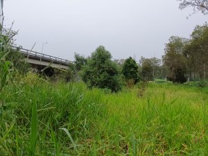
The track could have roughly followed of what is now Kings Avenue/Poinsettia/Progress Road in Inala and Richmond. Or more northerly as Baker mentioned it followed a ridge line. This could be from Bowhill Road via Azalea Street and Pine Road joining Progress Road to cross Bullock Head Creek and Wolston Creek.
However, a paper published by the Richland, Inala and Suburb History Group Inc. “Ipswich Road 1839 to 2005. The History of the Brisbane to Ipswich Road” provides the following information.
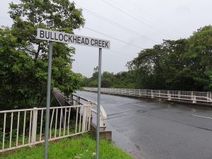
Picking up the road from Beatty Road, crossing the Oxley Creek and following Bowhill Road. The paper indicates the track skirts on the northern side of the Blunder Creek, it crossed the creek 200 meters downstream from Serviceton Avenue. It went through what is now the Inala Civic Centre towards Homestead Park. It followed Centaurus Street down the ridge to cross Bullockhead Creek to Tile Street then to Waterford Road, coming to Dingo Hill (current Gailes Golf Course).
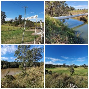
The information from Mark Baker indicates that before it reached Dingo Hill the track went through a ford at Woogaroo Creek at approx. three kms upstream from its confluence with the Brisbane River. Here it meets the Ipswich Rd again, it looks like the new road uses the same spot to cross this creek as the old convict track.
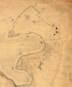
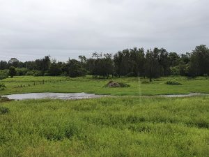
From here it looks like the old convict track follows the Ipswich Road – but more to the south of it – to the Red Bank outstation on Goodna Creek. According to the Dixon Map from 1842, the station was positioned between the road (now Brisbane Terrace and Brisbane Road) and Brisbane River along Goodna Creek. Interestingly in 2021 this area was still rural and could have looked like this in the convict era.
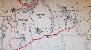
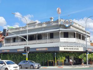
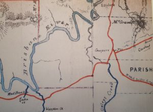
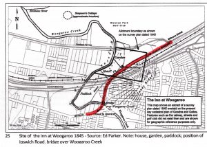
On of the very first ‘county hotels in Queensland was built in 1842, halfway Brisbane and Ipswich next to the Residence of Dr Stephen Simpson and the Border Police office in Woogaroo (see map below). Simpson had been the promoter of this hotel for the entertainment of his staff and visitors.The map also shows the details of the road in this area. The hotel operated under different names: Settler’s Arms, Woogaroo Hotel, Coach and Horses. A 2nd hotel was build 4 kms south near Bullock’s Head Creek, named Wolson Hotel, later renamed Halfway Hotel. This one did take significant busioness away from the Settler’s Inn. Both hotels have since disappeared. The Royal Mail Hotel in Goodna from 1864 (see below) is the remaining hotel in this area along the old convict road, which by that time had already become the new Coach Road. It is situated a mere 500 meters north from the original Settler’s Inn.
From here via the Six Miles Creek crossing and ascending the Iron Bark Ridges from where it descended to cross Bundamba Creek and then headed west to reach Limestone. The Coach Road was built over this stretch of the old convict road.
Other Early Roads
Road over Highgate Hill
There seems to be another road from South Brisbane to the north. This is mentioned in a paper published by the Richland, Inala and Suburb History Group Inc. “Ipswich Road 1839 to 2005. The History of the Brisbane to Ipswich Road”. This road appears on a survey plan from J. Galloway dated 24/11/1855. This road went from the ferry (Russell Street) via what is now Musgrave Park over Highgate Hill following current roads such as Hampstead Road, Dornoch Terrace and Gladstone Road. Here it joined with the newly developed Boggo Track at the current Gair Park close to the Boggo Road Gaol.
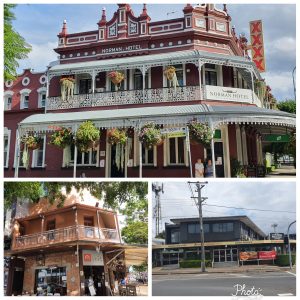
Hotels marking the trajectory of the Coach Road
With increased activity in Brisbane and perhaps even more importantly with the rich pastoral lands to the north and the west the importance of roads became more urgent and in the 1850s work slowly started to be undertaken both to the roads in town but also towards the Maranoa region and a road further to the north towards Maryborough. In 1852 Surveyor Burnett started to survey a new line of road. Wherever possible it followed the old road, but significant parts were also bypassed. Fortunately the new bridge build by Petrie as mentioned above over Oxley Creek fitted in with his plan.
Road building became more serious when Governor Bowen started to complain that he and his wife could not travel to Ipswich in their coach, the convict track was simply too bad. This led to a realignment of the old convict road, with most sections bypassing as there was no longer need for waterholes and bridges would be used to cross the various creeks were needed. In short, the road was now being made suitable so it could have a regular coach service between the two towns, which was launched in 1860.
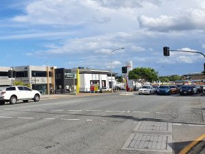
The start of Ipswich Road (a diversion from the earlier convict track) began with the development of the early five-way Woolloongabba intersection: Ipswich Road had been extended down the eastern side of the Boggo ridge to link up with the start of the road to the Logan district. The other road, Main Street, which met both roads, became the entry to the small township of Kangaroo Point.
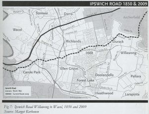
From here the new road basically bypassed the convict track all the way to Goodna. From there onward it looks like that it either was built here over the track or perhaps slightly north of it. From Riverview it looks like it followed the convict track into Ipswich, what is now the Old Ipswich Road and the Brisbane Road.
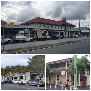
The following overview from Mark Baker of the early pubs that were established along this coach road gives a good indication of the trajectory of the road. It is not the most direct route between the two cities as various commercial and pastoral interests had to be considered.
Oxley Creek (1862); Crown Inn at Rocklea (1863); Bundamba (1863); Woolston at Darra (1863); Commercial at Redbank (1864); Royal Mail at Goodna (1864); Victoria at Four Mile Swamp (1864); Clarence at Woolloongabba (1864); Buffalo at Woolloongabba (1864); Junction at Annerley (1866); Woolloongabba at Woolloongabba (1868); Rocky Waterholes at Rocklea (1874); Norman at Woolloongabba (1890) and Chardons at Annerley (1892).
In 1873 the licensing of cabs and omnibuses commenced. The largest omnibus company in the area belonged to the John Soden and his family who lived just below Chardon’s Corner with their workshop.
As with any form of communications infrastructure it attracts business and soon land were sold along the route, which resulted in the arrival of new townships.
Village of Waverley, Annerley (1862); Queenstown Estate, Annerley (1864); Village of Egremont, Moorooka (1864) Township of Charleston, Darra (1864); Village of Melrose, Four Mile Swamp (1865); Township of Holmes, Goodna (1866); Township of Middleton, Ebbe Vale (1866); Oxley Township (1868).
With the arrival of the railway line between Ipswich and Brisbane during the early 1870s, the road system again had to take a back seat and maintenance budgets were severely cut. It was not until the arrival of the motor car that roads again received the appropriate attention and again it was the road between Ipswich and Brisbane that became the first to become a main road.
Boggo Road
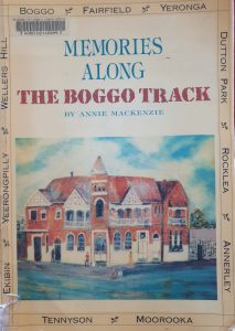 With settlers started to arrive in the early 1850s, at the Boggo Scrub (Fairfield and Yeronga) the Boggo track started to emerge (now Annerley Road). It formed, most probably upon an Indigenous track, and linked the One Mile Swamp with a pathway up to the top of the Boggo (Annerley) ridge; connecting it with the convict road (soon to become the Ipswich Coach Road).
It rapidly also started to function as an alternative (and drier) route (set of tracks) to Ipswich, via the South Brisbane Cemetery at Dutton park.
From here it went to Moorooka and used a new bridge at Rocky Waterhole, it went over a new bridge over Canoe (Oxley) creek towards Woogaroo and here it connected somewhere with the old convict road. It looks to me that it followed Blunder Street and linked in with the Old Convict Rd
Separately we also describe the various crossing from NSW via the Darling Downs into Brisbane . Squatters take possession of the Darling Downs
Squatters Highway
After the convict settlement was opened to free settlers there was more demand for land-based roads, especially from the squatters in the Darling Downs. The early explorers in the 1820s had established several tracks over the mountains, but they were all rather treacherous. For more details on theses track see here.
With pastoral activities rapidly increasing during the 1840s we see a lot of activities in relations to the transport of wool and other agriculture goods from the Darling Downs, Upper Brisbane Valley and the Fassifern and Lockyer valleys to Brisbane. With the ongoing indecisiveness of the British/NSW Government we see the same politics playing out as in other parts of the emerging Queensland society. The squatters tried to undermine Brisbane becoming the main town in Queensland and instead favoured Ipswich and Cleveland (the latter as a sea port). To facilitate the squatters Chambers and Petrie in 1842 built a store wharf on Brisbane River in Red Bank, but this was boycotted by the squatters and the venture collapsed.
In 1853 a German firm from Sydney opened a shipping business and The Australian Steam Navigation Company put a steamer on the Sydney to Cleveland run. A large wool store with offices, bonding store and cottages was build here as well. In the end it all failed.
In the meantime however, the squatters organised a road (the squatters’ highway) from Ipswich via Cowper’s Plains to their preferred port at Emu Point. However, while the township of Cleveland was established and a wool store erected in the end this settlement faced the same problems as the initial convict settlement at Red Cliffe, Moreton Bay was too shallow, direct sea transport used the north passage with direct access to the Brisbane River, where dredging had started to be undertaken. Nevertheless by 1861 the squatters’ highway was surveyed from Cowper’s Plains via Rocky Crossing and Tingalpa Creek to Cleveland (the current Mount Gravatt – Capalaba Road). In other parts it largely still survives as the Old Cleveland Road.
Traversing d’Aigular Range
Another route from the Upper Brisbane River Valley to Brisbane started to emerge after the squatters Edmund Uhr and John Ferriter (River Station later Wivenhoe Pocket Station) paid for a route bypassing Ipswich and in 1846 blasted a crossing on the D’Aigular Range. From the Upper Brisbane area via Petrie, Mt Zion (the German Mission at Nundah), Eagle Farm and Breakfast Creek to Brisbane. However, the squatters in Ipswich posed such a road as it wanted the produce from the Darling Downs to pass through their town. While occasional improvements of the track were made it never was of such quality that it could be used for efficient (wool) transportation.
In the 1930s Pine Shire Council was happy to except funds to construct a road from Enoggera to Mt Nebo for the purpose of tourism. This would be part of a more eastern route over d’Aigular and an extension of the Waterworks Road from Enoggera to Brisbane. Ongoing opposition from the the Upper Brisbane River Esk Council made it sure that very little progress was made. They finally saw the light after the construction of the Wivenhoe Dam in the 1970s. The tourism potential was now real and the decision was finally made in 1985 to create the link via the Northbrook Parkway to Mt Glorious where it linked in with the road via Mt Nebo.
Moggill Road
t was not until 1849 before a road was surveyed from North Brisbane to Ipswich (the current Moggill Road). This would have been a far more direct road, be it for the lack of a bridge over the Brisbane River. It followed the riverbank on what became known as River Road and later Coronation Drive. For a short time, there was a toll house at where is now the Regatta Hotel, however strong protest from the farmers saw a quick end to this. From Toowong onward the name retains its original name of Moggill Road linking it to the farming and forestry areas of Kenmore, Brookvale, Fig Tree Pocket and Pullen Vale. It was also used for the transport of coal as in 1848 a small coal mine started to operate here.
W. Baker discovered a new road from Moggill to Smith’s hotel at Wivenhoe, it was opened in 1850 and became known as Baker’s line and is the forerunner of Mt Crosby Road. This saved 26 kilometers of a trip for the settlers in the Upper Brisbane Valley. This road was further extended to Taromeo and Nanango. In all this road, from Nanango to Brisbane now stretched 120 kilometers.
A planned bridge over the Brisbane River – to establish a northern route to Ipswich – did not eventuate and from 1873 till this day the crossing is serviced by a ferry. Here – at Redbank – it was connecting to the convict road to Ipswich. Finally a bridge was built at Fig Tree Pocket in 1964 to create this much shorter northern route from Brisbane to Ipswich.
Without a bridge or a proper ferry crossing the road was mainly used by the farmers in the northern district who drove their cattle over this road and delivered their wool on the bullocks pulled drays to Brisbane. Sawyers used it to transport their timber alternatively it was rafted over the Moggill Creek to Brisbane. The land here was one of the earliest surveyed outside the CBD and was subdivided for farmers, sawyers and early immigrants who came from Scotland, Ireland, Germany and of course England.
As was the case with all the other roads in Brisbane, maintenance was often non existing, and this road was often impassable. While drays could be pulled through the mud and the ruts. Horse traffic was often not possible.
In 1850 a separate track was built through the hills via Mount Crosby to College’s Crossing (see above). This was the first spot where the Brisbane could be crossed, before the Victoria Bridge was built in town. At this crossing it was possible to wade through the river to the other side and eventually end up in Ipswich. Low level bridges followed later.