It were convicts who ‘discovered’ the River
The British Government had decided to establish a new penal settlement in the northern parts of what at that stage was NSW. Consequently Surveyor General Lieutenant John Oxley was send out to explore that region. He left Sydney on October 21, 1823 and sailed in the schooner HMS Mermaid north as far as Port Curtis (the site of Gladstone). On the way back – on November 29th – the ship entered Moreton Bay. They anchored at Point Skirmish at the entrance of the Pumice-stone River. That is, he thought that the bay was the entrance to a river (Pumice-stone Passage) when he found out he changed the name in Deception Bay. From here they surveyed the area at Red Cliff Point.
To his surprise – at what is now called Bribie Island, Oxley came across stranded ticket of leave Thomas Pamphlett and a day later full convict John Finnegan, among a large group of Aboriginals.
They both were members of an original party of 4 convicts from Sydney who in March that year were shipwrecked and ended up on Moreton Island. John Thompson hadn’t survived the ordeal. The 4th person Richard Parsons miraculous arrived back home in Sydney 9 months later.
The three survivors began to make the trek north, where they thought Sydney was situated. They tracked for 7 months staying on and off with Aboriginals, who saw them as dead ancestors. While Parsons decided to continue to travel north Pamphlett and Finneganstayed with the local Turrbal people who allowed the two to live with them and provided them with food. During this period, they also travelled into a river that some Aboriginals called Maiwar and later became known as the Brisbane River. They walked along the river for a month before they stole an Aboriginal canoe and made their crossing of the river. Oxley named it Canoe Creek, but two years later Edmund Lockyer charted the Brisbane River and described the tributary as Oxleys Creek (Graceville). They used the canoe to return to the mouth of the river and continued north. They reached Bribie Island sometime between July and October 1823.

Finnegan under pressure, showed Oxley and his party the river. However, he led them to the wrong river. When Oxley realised it wasn’t the Brisbane River, he named it “Deception River”, but “North Pine” river eventually stuck because of all of the Hoop Pines that grew along the river’s banks. This was the 2nd ‘deception’ of Oxley in the same area.
However, the next day together with Lieutenant Stirling they took the whaleboat and provisions for four days to explore the river they were looking for. It was Stirling who mapped the river (Oxley mostly gets the credit for it). They sailed about fifty miles (80 km) up the river and reached, what Oxley named, Termination Hill (now Wolston at Wacol). He mentioned the rich soil and the good timber along the river. They reported fresh river water up to around 18 miles (29km) from the mouth of the river. At 30 miles (48km) the river meandered through ‘magnificent flat country’. Afterwards Oxley named it, Brisbane River, in honour of the Governor of NSW Thomas Brisbane.
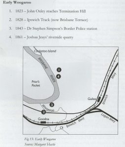
Interestingly, twenty years later at Termination Hill, the spot where Oxley stopped, Dr Stephen Simpson established here the Boarder police Station where the convict road from Brisbane to Ipswich met with Brisbane River.
Already as this stage Oxley saw the potential of the river being an excellent opportunity for settlement. This is what reported:
“The Brisbane River presents so many superior situations that, although a port at Red Cliff Point may in the first instance be indispensable, yet the country on the west side of the river at the termination of the Sea Reach, appears to me a much better site for a permanent establishment. The river is not fresh there, but there is plenty of fresh water; the country is open and no obstacles exist from swamps or hills to prevent a ready communication with the interior, either by the banks of the river, or at a distance from it. The water is deeper closer to the shore and vessels of considerable burthen could load or unload close to the bank. From a hill near this last station, the entrance of the bay can be seen; and by clearing a few trees, communication by signal may be held with Red Cliff Point”.

In the end he did not suggest a settlement along the river but reported that the best place for the penal settlement was ‘Red Cliff Point’, at the cliffs off Scarborough point, the latter was named by Matthew Flinders during his 1799 voyage.
On Saturday the 6th of December, the party left Moreton Bay and went back to Sydney. Pamphlett and Flannagan were also on board. Back in Sydney 18 months later Pamphlett committed another crime (stealing two bags of flower) and was send for 7 years to the new penal colony of Moreton Bay. His name lives on in Brisbane in the Pamphlett Bridge in Graceville, over the Oxley Creek.
Establishing the penal colony and 2nd exploration of the River
On the 29th of August 1824, Lieutenant Henry Miller together with Oxley left Sydney and arrived in Moreton Bay in the brig Amity on the 10th of September and established the Moreton Bay Penal Colony at Red Cliff.
Governor Brisbane also gave Oxley detailed instruction regarding a survey of the river and its shores and possible establishing its source. So the possibilities of the river were of interest from the very beginnings.
Later that month Oxley and Cunningham surveyed for two weeks the river on board the Amity. They met an Aboriginal group at the mouth of a creek approx. 9 kms from the mouth of the river. After they had breakfast at the site a minor conflict with the aboriginals arose after one of them grabbed Oxley’s hat. Oxley named it Breakfast Creek in remembrance of the incident.

They explored what is now called Western Creek at Milton and noted that this could be a potential area for the settlement. There is also a plaque at North Quay opposite Marketon Street indicating that Oxley landed here. However, historici have debunked this story. They continued to Termination Hill and from here on they continued and named the Bremer River, they did not explore it.
The Amity with Oxley and Cunningham on board left Moreton Bay for Sydney on the 17th of October.
This time he left Moreton Bay via the South Passage and became the first European sailor known to do so. This also became a game changer for the potential of a settlement on the river as the discovery of the South Passage made the trip to the river much faster.
The Amity arrived back in Sydney four days later. They had also brought with them a stack of wood from new pines they had discovered along the river. They are the Hoop Pines and received the official name as Araucaria cunninghamii in honour of the botanist and explorer Allan Cunningham. A stand of them have been replanted in the Roma Street Parkland. The Aboriginal name for this tree is Kumbartcho.

On November 9th, the Amity left Sydney again bound for Moreton Bay. This time with Governor Brisbane, Oxley and other officials keen to visit the new settlement. Accompanied by John Oxley he also cruised the river to a site 9 to 10 miles from the mouth of the river (to Breakfast Creek). Oxley suggested to move the settlement at Red Cliff to this spot, the Governor agreed with that. At the time the Red Cliff settlement was established there was not enough information about the river. This had only become clear after Oxley and Cunningham two week long trip over the river in October. Also at that time the southern entrance to the Bay was unknown. The party with the Governor stayed overnight on the river before turning back.
The third river exploration
The next person to investigate the river was explorer Lieutenant Edmund Lockyer. In August 1825 he was ordered to explored the upper reaches of the Brisbane River. On 2 September, Lockyer sailed from Sydney in the cutter Mermaid, arriving at the settlement of Brisbane on 7 September. Leaving the Mermaid in Brisbane, he travelled in a small boat up the river. Lockyer saw coal in deposits on the banks, becoming the first person to identify coal in Queensland. He also explored the Bremer River along which Ipswich developed. Non of the early explorers reached the source some 330km upstream at Mt Stanley in the Great Dividing Range. Lockyer named the mountain range in the area of where he thought the source was the Brisbane Mountains, others further along he named the Blue Mountains. These name didn’t stick.

Major Edmund Lockyer in January 1827, was also the man who formally annexed Western Australia on behalf of the British at Albany overriding the Dutch claim to New Holland. The move was motivated by rumours of French interest in Western Australia.
Logan’s expeditions (1,2 and 3)
Captain Patrick Logan was another passionate explorer and spend a considerable time in the are. On his first expedition in 1826 he went south into the Bay he discovered the Logan River (obviously the local people knew this already for thousands of years). On his 2nd expedition the following year he went even further south and discovered the Coomera River. On his 3rd trip that same year he investigated the Bremer River. Here he discovered deposits of limestone at the site of what was to become Ipswich.

He explored the Fassifern Valley and became the first Europeans to cross the Flinders Peak range an unnamed range of hills located on the northern edge of the Scenic Rim Region, south west of Logan City and south east of the City of Ipswich. This is such a distinct mountain range recognisable from Brisbane CBD (and our apartment). The summit in the Range is Flinders Peak (Aboriginal: Booroong’pah) reaching 680 metres. This mountain was originally named High Peak by Lieutenant Matthew Flinders in July 1799. John Oxley during his explorations in 1824, changed the name in honour of Flinders. Logan climbed Mt French and he marvelled about the good land that he could see from here, ideal for pasture. He tried to climb Mt Barney (which he thought was Mount Warning) but the scrub here was too thick.

Cunningham ‘discovers’ the Darling Downs
Again of course the local Aboriginal people know this are inside outside but it was Allan Cunningham who was the first European to enter the area. He was in the area at the time that Logan was on his third expedition. Cunningham this time travelled overland from the Hunter Valley to New England and crossed the Condamine River (near Warwick) from here he followed the Glengallen Creek. He named the area in honour of the the NSW Governor of that time Ralph Darling. Downs is an English name for rolling pasture lands. Similar to Logan he marvelled about the rich pasture lands.
He climbed Mt Dumaresq and from here to the north he named Peel’s Plains (now Clifton Plains). The plains to the south and south south east he named the Canning Downs in honour of the Right Hon. George Canning. A large grassy valley on its northern side of the mountain he called Millar’s Valley. While his intention was to explore further – and cross the mountain range – wet weather and low rations forced him to travel to Moreton Bay.

Logan 4th expedition together with Cunningham
The following year, on July 27th, Logan and Cunningham joined forces to see if they could cross the mountain range.
According to information on the website of Logan City it has been suggested that this time Logan’s route seems to have been through Rocklea and across the edge of Archerfield Aerodrome to Acacia Ridge. Here they crossed Oxley Creek, probably in the Willawong area. They followed Oxley Creek southwards on the western crossed back to the eastern side – not an easy task. They passed through Greenbank, camping that night beside a small creek, possibly Norris Creek.
They continued south until they reached the Logan River, just east of McLean’s Bridge. The group continued southwards to Mt Barney. They started the climb the mountain. Cunningham only climbed to one intermediate ridge. Logan however, continued his own and was finally able to reach the top. The ascent and the descent were both near impossible tasks. Once at the top that this was not Mount Warning. The peak he had climbed was called Mount Barney in honour of George Barney, Colonial Engineer.
 from Boonah")
According to Logan’s report: “A range distant scarcely ten miles [about sixteen kilometres] of elevated, bold appearance was named Macpherson’s Range in compliment of Major Macpherson of His Majesty’s 39th Regiment. The mountain which we visited, which is the easternmost of the range, was named Mount Lindesay as a compliment to the officer commanding His Majesty’s 39th Regiment in this colony.’ Another peak, a few kilometres to the south of it, was named Mount Hooker after Cunningham’s and Fraser’s friend William Hooker, Professor of Botany at the University of Glasgow.”
When the area was surveyed in 1840 Cunningham’s map had been temporarily mislaid and the name Mount Lindesay was given to Cunningham’s Mount Hooker.
On the 5th of August Logan had to return to Moreton Bay. Cunningham continued the expedition.
He travelled up the valley of the Bremer. A few days later they arrived at the stony foothills of the Great Dividing Range. The task at hand was to find a pass to cross the divide. He recognised the gap that he had seen on his explorations the previous year. The reached the gap – that would bear his name – with reasonable ease. Squatters arriving in the 1840s – with drays – however, did find the pass very hard to use and it was largely abandoned in favour of the slightly less treacherous Spicer Gap.
River explorations
Both Logan and Cunningham separately explored the river. Cunningham went to the source of the river and established that it didn’t start in a vast inland marshland, but that it originates on the eastern side of the Great Dividing Range. Logan in 1829 followed again the Brisbane River to the vicinity of Mount Brisbane and, the following year , he explored past his `Mount Lindesay’ to the headwaters of the Richmond River. On his 7th expedition – again towards the headlands of the Brisbane River – he was killed in the what is now called the Somerset Region as mentioned here.

The start of the Moreton Bay Convict Settlement and Penal Colony at Red Cliff