Squatters taking the land from the Aboriginals and got wealthy and influential
Well before the opening up of the penal colony of Moreton Bay for free settlers, squatters started to arrive. Based on lessons learned in other colonies such as America, South Africa and Canada, sons of the wealthy aristocracy and gentry of England and Scotland were send to Queensland (northern NSW) to start claiming land. Many of them were big landholders back in the mother country. Moving further north into Australia, they simply took the land by disposing of the local Aboriginal people and if necessary killing those who didn’t want to give up their ancestral country. In late 1830s and the early 1840s, they adhered to the 50 miles exclusion zone around the penal colony and started to settle in the Darling Downs. After that they rapidly moved closer to Brisbane as well as further north, continuing their land grab. This is the period of the Border Wars between the Aboriginals and the white settlers, supported by the Native Border Police.
These squatters used their extensive political, economic and social influence in London, Sydney and later Brisbane to dominate proceedings in relation to access to convict labour, getting personal support of the Native Police (to kill Aboriginals) as well as the Legislative Council to increase their wealth at the expense not only of the Aboriginal people but also of new settlers. The latter for example opposed further convict transportation.
They were opportunistic using squattering to take control of large swaths of land. Once they had completed their land grabs most of them would return back to England, enjoying the spoils of their wealth or ended up as an oligarchy, basically ruling the new state of Queensland when it gained independence. They were appointed for life in the Upper House, until 1922 when this House was abandoned.
According to Wikipedia, the term ‘squatter’ derives from its English usage as a term of contempt for a person who had taken up residence at a place without having legal claim. The use of ‘squatter’ in the early years of British settlement of Australia had a similar connotation, referring primarily to a person who had ‘squatted’ on ‘unoccupied’ land for pastoral or other purposes. In its early derogatory context the term was often applied to the illegitimate occupation of land by ticket-of-leave convicts or ex-convicts (emancipists).
From the mid-1820s, however, the occupation of Crown land without legal title became more widespread, often carried out by members of the British aristocracy and the gentry and others from the upper echelons of colonial society. As wool began to be exported to England and the colonial population increased, the occupation of pastoral land for raising cattle and sheep progressively became a more lucrative enterprise. ‘Squatting’ had become so widespread by the mid-1830s that Government policy in New South Wales towards the practice shifted from opposition to regulation and control. By that stage, the term ‘squatter’ was applied to those who occupied Crown land under a lease or license, without the negative connotation of earlier times.
The early settlers lived next to each other in for example the Darling Downs, Fassifern Valley (Scenic Rim) and the Upper Brisbane River Valley. They depended on each other as there was no infrastructure, no government services, no close by towns or villages. Once the government became involved they had to wait and see if they could stay on the land they occupied and how much they eventually had to pay to obtain the title of it. As mentioned they themselves had a great influence in the policy and legislation that governed this. In general the squatters got their way and changed into proper landowners.
By now the term squatter had developed a class association, suggesting an elevated socio-economic status and entrepreneurial attitude, they saw themselves as the new landed gentry with privileges. By the 1840s squatters were recognized as being among the wealthiest men in the colony of New South Wales. Not long afterwards also the squatters who settled north of Brisbane joined these ranks.
In 1842 Governor Gipps reported 45 squatting stations scattered around Brisbane.
For the first few decades of the Brisbane free settlement they were the main drivers of the agriculture-based economy. They indeed made lots of money. but at what cost especially in relation to a rapid dwindling Aboriginal population.
Their behaviour, especially in our eyes is totally unacceptable, but that is not to say that these settlers didn’t work hark. The aristocratic sons who settled here had a tough life in front of them. During all that time they still had to totally rely on themselves. On arrival on the lands they would occupy everything had to be set up from stretch with little or no access to supplies. It started with tents, followed by slab huts and often much later ‘proper buildings. Of course as has been the case since time immemorial, farming goes through booms and busts. There was a severe economic depression in 1842 and the price of sheep was so low that it made more sense to boil down sheep for fat. This resulted in the development of a couple of boiling-down plans in Brisbane and for a while the production of tallow saved the community during this down turn. Soap factories and leather works followed soon. Similar works started to appear in Ipswich, providing a healthy level of competition.
They were the ones that created the first roads and slowly around them others started to gather and small villages emerged.
A continuing shortage of labour was the key reason that agriculture didn’t really develop on the Downs. It was left to local farmers around Brisbane to provide supplies for the local population and in 1845 the windmill was put to work again for local milling. As mentioned, the squatters lobbied for decades to keep the convict transportation going as this supplied them with cheap labour.
The Aboriginal Wars.
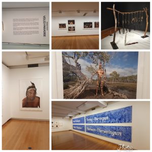
The situation for the Aboriginal people however, started to deteriorate sharply after the convict settlement was closed. Until that time settlement was limited to the penal settlement while there were problems the Jagera, Turrbul, Gidhabal and Jarowair people living in this area. After the lands were opened up the squatters flooded in. The Moreton Bay area and beyond started to see large numbers of new settlers. As the squatters extended their properties and more started to arrive, the Aboriginal people were pushed of their lands. They obviously didn’t take this laying down and significant armed resistance took place, especially between 1842 and 1844. In 1842 the last Penal Colony Commander had left Brisbane and while the official authority was situated in Sydney, the area was basically left to their own. Most squatters were magistrates and therefore had a certain level of legal authority. They requested military assistance from NSW to fight against the Aboriginal population. During the 1840s the number of soldiers increased from 20 to 50 and at its peak close to 100. Magistrate squatters could demand the soldiers to come and assist to rid them of Aboriginal people who objected the take over of their land. As a consequence thousands of people were killed by the Squatters and their soldiers as spears were no match for guns. The military never intervened in the massacres and killings on behalf of the Aboriginals. Towards the end of the decade the armed rebellions were broken and in 1850 the last British soldiers left Brisbane to be replaced by a locally formed militia and soon there after the Native Police arrived in the area who killed even more Aboriginal people over the following decades.
While some of the squatters were able to build up good relationships with the Aboriginal tribes, nearly all were in one way or another, direct or indirect also involved in the murder of Aboriginals. While low in comparison also some squatters and their staff were killed by Aboriginals.
Darling Downs – preferred by the squatters
As mentioned here, Allan Cunningham had set out to explore the area to the west of Moreton Bay in 1827, crossing to the west of the Great Dividing Range from the Hunter Region and travelling north. In June 1827, he noticed a potential pass, but was running out of time to explore this further. This happened a year later and the pass became known as Cunningham’s Gap. He named the mountains on each Mt Mitchell and Mt Cordeaux after the Surveyor General Thomas Mitchell and his assistant Willian Cordeaux. Back in Sydney he reported on the excellent pastures in the Darling Downs.
In 1828 Cunningham and Logan also explored a crossing over the Macpherson Range (part of the Scenic Rim) to the Logan Valley. The plan was to use the pass to drive cattle overland to Port Macquarie, however, this plan was abandoned, in favour of using shipping transport.
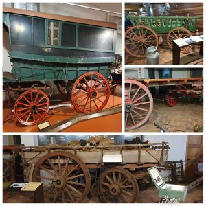
A year later Cunningham drew Mt Mitchell, Mt Cordeaux and Spicer’s Peak from the windmill (Wickham Terrace) in Brisbane. Peter Spicer was the overseers of the convicts at the penal settlement. Cunningham’s Gap, however the track was unsuitable for drays (massive two wheeled carts with one bullock in the shafts and one in front) and was only used for those on horseback until a proper road was build in 1926. Nevertheless as early as 1846 an inn was operating at the foot of the Gap at Fessifern Reserve on Warrill Creek.
News of the lush pastures quickly spread resulting in a land grab. This coincided with a boom in the wool industry. There was big money to be made for the pastoralists and those with capital were eager to find new pastures to grow sheep.
With more settlers arriving and increased produce from the Darling Downs needed to be transported, the need for a better road grew more urgent. Initially supplies for these squatters had to be brought overland from Newcastle, through Maitland, Tamworth, and Armidale.
Basically a road was needed from Warwick and the southern Darling Downs traversing the Great Dividing Range to Limestone (Ipswich) and on to Brisbane. From Ipswich there was the option to use ships via the Bremer and Brisbane Rivers or to continue by road via Redbank.
The first squatters on the Downs
Scotchman Patrick Leslie, in 1836, especially travelled to Australia to learn about flock management at the politically very influential Macarthur’s at Camden, NSW. He as well as his brother George married their daughters, thus extending the Macarthur influence to Queensland as well. This also resulted in bringing Pure Merinos to Queensland.
He consulted Cunningham and became the first person to settle on the Darling Downs in 1840. Together with his brothers he established a sheep property at Canning Downs on the Condamine River in 1846. Patrick Leslie also built, the still existing, Newstead Home in Brisbane which he later sold to the ‘pre-governor’ John Wickham. Patrick Leslie is also regarded as the father of stud breeding in Queensland.
Arthur Hodgson and Gilbert Elliott (Eton Vale) were the next squatters to follow. In 1840 they travelled via Limestone (Ipswich) to Brisbane to visit Commander Gorman. After their return to the Darling Downs, Gorman decided to see for the area for himself and search for a much needed route for drays. The Cunningham Gap was to steep for this form of transport. He established such a route via the Flagstone Creek through a gap that became known as Hodgson’s or Gorman’s Gap. However the route towards the gap was prone to flooding and thus very treacherous, it became known as Hell Hole. Arthur Hodgson did find a better route but in the end the road from Toowoomba to Ipswich was established via Toll Bar and Helidon (now part of the Warrego Highway).
Explorer and historian Henry Stuart Russell was a guest at the Elliott’s at Eton Vale on the Darling Downs. In 1841 together with his brother Sydenham Russell they became pastoralists and took up Cecil Plains on the Darling Downs and occupied it until 1849.

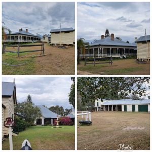
Another early pastoral stations to be established was Jimbour House. This property was first claimed by Henry Dennis on behalf of a Scotsman called Todd Scougall in 1842. However, it was developed by Thomas Bell who bought it 2 years later. The homestead still exists and is unique in Queensland as the only genuinely grand country house in the English manner to be built in the state.
Other well-established residences on the southern downs include Glengallan Homestead, Talgai Homestead, Pringle Cottage and Rosenthal Homestead.
By 1844 there were 26 properties including several sheep stations with more than 150,000 head. Many of them owned by landed British gentry. Darling Downs then became known as the ‘jewel in the diadem of squatterdom’ with an elite ‘pure merino’ class living in comfortable houses.
In 1854, Charles Douglas Eastaughffe settled in the area. Spicers Gap Road opened the area in the 1850s.
The Squatters of course also had to be in Brisbane at regular times and many of them would stay in The Sovereign in Queen Street. It was the most reputable hotel in town and the first publican was George McAdam. He had arrived with a group of settlers who travelled with George and Patrick Leslie to the Darling Downs. McAdam was a groom at the Leslie’s before he became a publican. He maintained a business relationship with the Leslies’s (horsetrading). Through McAdam there was a strong link between the Darling Downs and Brisbane.
Spicers Gap

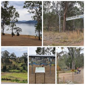
Landowners in the Southern Darling Downs such as Leslie and Bracker however, continued to look for a better pass. In 1847 Leslie’s stockman Henry Alphan found one over the Main Ridge. This was first known as Main Gap and later as Spicer’s Gap. Situated only 4 kms south of Cunningham’s Gap. Between Mt Mitchell and Spicer’s Peak. As mentioned above, both these mountains were named by Cunningham in 1827. Henry Alphan received approval to establish an inn on the western side of Spicer’s Gap (later known as Jubb’s Inn).
However, none of the “Gaps” were easy and there are far more complaints about these early roads than there is praise. Yet, until 1926, Spicer’s Gap remained the only feasible route for drays to travel over the Great Dividing Range. The alternative would be to circumvent the ranges and travel via Toowoomba.
What many travellers however did describe were the marvelous view on the Spicer’s Gap Road from what is now called Governor’s Chair. Named so as several Governors enjoyed the views from this spot.
With basic infrastructure in place, the postal service was also expanded to the Darling Downs.
Settlers in the Upper Brisbane River Valley (and beyond)
With the closure of the penal colony, early settlers came from the Downs via Gorman’s Gap and Lockyer Creek to settle on the Brisbane River. These were:
- the McConnel brothers who settled in Cressbrook,
- the MacKenzie brothers in Kilcoy,
- the Brothers Bigge, neat Mt Brisbane,
- the Archer brothers at Durandur,
- Gideon Scott at Esk,
- Ferriter & Uhr at Fernvale and Wivenhoe; and
- Balfours at Collington
Cressbrook Homestead established by David Cannon McConnel in 1841, who came from the village of Cressbrook in Derbyshire, England. He was an exception to the usual squatters as David was a a much more progressive pastoralist. Rather than relying of convict labour, or lobbying for this, he employed a large number of emigrants brought into Brisbane by Dr Lang. His elder brother John had a run at Crows Nest for a time and then joined his brother. They soon found that Cressbrook was unsuitable for sheep. David bought stud Shorthorn cows from the Australian Agricultural Co. in 1845 and later imported bulls from England, establishing a stud which became famous.
Leaving John in charge of Cressbrook, David returned to England in 1847 and settled on a farm in Nottinghamshire but was recalled to Queensland because of financial difficulties at Cressbrook. He took up land at Toogoolawah (Bulimba)
where he built a large house in 1850, began farming on his own account and sold small blocks cheaply to deserving immigrants. He travelled extensively throughout Europe. In 1868 half his run was resumed by the government and 5 years he retired in favour of his son James. He died in London in 1885.
The Cressbrook property is still owned by the McConnel family.
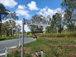
Not far from here is Gregors Creek named after the Squatter Andrew Gregor who was killed here on 10 October 1846 after being attacked by Aboriginals.
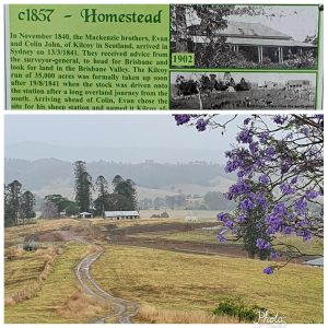
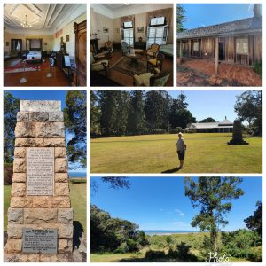
In 1841, the Scottish McKenzie family settled close by in what is now Kilcoy. Evan and Colin John took up 35,000 acres and brought their sheep across from the south. But more importantly they had also brought with them free, educated workers from their father Sir Colin McKenzie’ estate from Kincoy Castle, Ross Shire, Scotland.
A year later, together with the Archer Brothers, they opened up a road from their properties to North Brisbane, keeping the D’Aguilar Range to their right crossing the numerous creeks that flowed into Moreton above the tide line, arriving at the German Mission (Nundah) and from here via the bridge over Breakfast Creek.
1843 The Mackenzie’s purchased a wool store in Brisbane and built the first licensed hotel in South Brisbane. They later acquired hotels in Brisbane City and in Ipswich.
The station was sold in 1849 to Charles Atherton and five years later to Captain Louis Hope (the seventh son of the Fourth Earl of Hopetoun). In 1908 the homestead was sold to William Butler, who is still greatly remembered in Kilcoy. Hope, purchased the land near Cleveland that in 1861 would became the Ormiston Plantation. Together with Francis Bigge (see below) they were key supporters of making Cleveland the key port and the capital of the new State of Queensland.
After the death of his father in 1845, Evan went back to Scotland and succeeded to the title. Colin followed in 1857.
Francis Edward Bigge
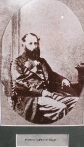  In 1839, Francis Edward Bigge left the Navy, and travelled to Australia, to join his elder brother Frederick William Bigge, who had settled in New South Wales. After his arrival in NSW, the two brothers were inspired the success of the Leslie Brothers, who pioneered the Darling and decided to try settling in the Moreton Bay district. They travelled overland to the Moreton Bay area in about 1842, where they “squatted” in the Mount Brisbane district, their headquarters being known as “Bigge’s Camp”. They were nicknamed “Big Bigge” (Frederick) and “Little Bigge” (Francis). In the 1840s and 1850s squatters from the Darling Downs and Ipswich interests urged for recognition of Cleveland Point, which had served as the port for Dunwich during the convict period, as the port for Moreton Bay. Francis Bigge was one of the leading lobbyists. In the early 1850s he invested heavily in industry and housing at Cleveland. From September 1851 to December 1852, Francis Bigge was elected to the NSW Legislative Council representing the Pastoral Districts of Moreton, Wide Bay, Burnett and Maranoa. He championed the development of Cleveland on Moreton Bay. He was influential in achieving the separation of Queensland from NSW but failed in making Cleveland the capital of Queensland |
The Archers‘ where of Norwegian origin, William became a timber merchant in Scotland from where seven of his sons traveled to Australia. David was the first to arrive soon joined by Thomas and William. They were keen to squatter in the Darling Downs, however by the time they arrived there in 1841, these lands were already taken. They explored what they called Brisbane Valley, by that time they were also joined by John and the four settled at Durandur (Woodford), a holding of 500 km2. Here they were joined by Charles, accompanied by the explorer Ludwig Leichardt (see below). However Durandur was unsuitable for sheep and they went further west – following the reports that Surveyor Thomas Mitchell had written about this region – here they took up lands at Cooyar and Emu Creek.
In 1848, Thomas crossed the Burnett river near Gayndah and traveled further north to take up a holding in Eidsvold (named after their property Eidsvoll in Norway). Interestingly the town that started to develop here (Gayndah) became in 1853 – when it had a population of 100 – a potential rival to Brisbane as the new capital for a at that stage still potentially new state. While small it was central in the rapidly expanding pastoral industry.
I very much enjoyed reading the letters from the Archer Brothers back to their parents in Norway as they have been published by Brisbane History Group in “Brisbane River Valley 1841-1850. Pioneer observations and reminiscences”.
In 1853 Charles and William also crossed the Fitzroy River at Gayndah they named the river in honour of the Governor of NSW). They were the first Europeans to explore the river valley.
Two years later they returned and set up a run, naming it Gracemere (in honour of Thomas’s new wife Grace) They named Rockhampton, the river was navigable until the rocks that lay across the river here, their supply ship the Ellida, sailed by Colin Archer, landed here and a small hamlet evolved along the river port that has grown into the current city. After years for exploring the Archers finally settled at Gracemere, were Archibald joined them in 1860. He became an MP and a colonial treasurer and minster for education. Thomas became Agent-General for Queensland in London, representing the commercial and diplomatic interests of the State. Charles became a police-magistrate in Rockhampton. Colin went to Norway and became well known as a naval architect, builder of the Fram – for the Arctic and Antarctic explorer Fridtjof Nansen – and designer of the unsinkable sailing “Rescue Boats”. William became famous as a dramatic critic, playwright, and miscellaneous writer in Norway. John returned to his occupation as a sailor and was lost at sea. Another brother Alexander became a bank manager he married Mary the daughter of Sir Robert MacKenzie, Premier of Queensland. Both Mary and Alexander died in the 1890 sinking of the RMS Quetta.
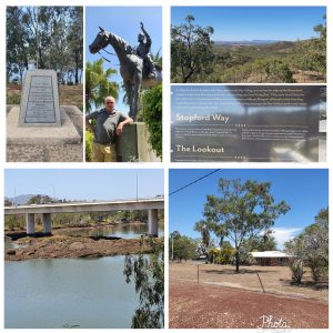
Leichhardt at Durundur (text on the plaque at Woodford)
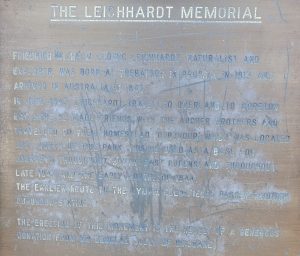
Friedrich Wilhem Ludwig Leichhardt, naturalist and explorer was born at Trebatson in Prussia in 1813 and arrived in Australia in 1842.In June 1843 Leichhardt travelled overland to Moreton Bay where he made friends with the Archer brothers and travelled to their homestead ‘Durundur’ which was located just north of this park. This he used as a base for journeys throughout South-East Queensland throughout 1843 and the early months of 1844. The earlier route to Gympie Gold Fields past through Durundur Station. The erection of this monument is the result of a generous donation of Mr. Douglas Jolly of Brisbane |
Gideon A. Scott bought the property named Mount Esk in 1842. This forty-five thousand acres run was surrounded by mountains but had some fine river flats. The town of Esk is on part of the old lease.
Francis Bigge bought the the property in 1849 incorporated into his Mount Brisbane station, making this a total of 79,497 acres. Gideon tragically drowned in Moreton Bay in January 1863, aged 42.
In 1848, John Stephen Ferriter (from Ireland) and Edmund Blucher Uhr ( from Swedish decent) arrived from Tent Hill in the Lockyer Valley and squatted on 38,000 acres (150 km2) close to limits of convict colony of Moreton Bay and called it Wivenhoe Run after the town in England. They grazed sheep and built two single roomed huts. The eastern hut was called Wivenhoe Homestead and the western slab hut was called Bellevue Homestead. A conflict with Aboriginals defending the usurpation of their lands led to the death of John Uhr. The family were forced
to move to the Wide Bay-Burnett region. In Maryborough of Edmund Blucher Uhr. After setting up a pastoral run at Mundooya, they settled at the township of Maryborough became a magistrate and the proprietor of a boiling down establishment. Here we came across the site of the former home of the family on Wharf Street.
Uhr and Ferriter needed better access from the Upper Brisbane Rive region to Brisbane they paid for a route bypassing Ipswich and in 1846 blasted a crossing on the D’Anguilar Range near Nebo to Brisbane. (Current Waterworks Road).
In 1849 Ferriter and Uhr dissolved their partnership by mutual consent and moved to the Burnett district, selling Wivenhoe to anther squatter another squatter family; the North’s. They descended from an British/ Irish barony. They arrived in 1837 in Sydney and moved into the Brisbane River area two years later. Here they owned property in Fairney Lawn and Northbrook and also owned Bellevue at that time. The Wivenhoe property disappeared with the construction of the Wivenhoe Dam in 1983.

John Stephen Ferriter eventually ended up in Brisbane where he mentioned as the Agent for Immigration, and lived in a cottage adjacent to the stone barracks between George and William Streets, afterwards the Colonial Treasurers’ Office. He died there in 1865 and was buried at the cemetery at Paddington. His former partner Edmund was at his funeral where it is said he remarked that John was “somewhat addicted to bad puns, but otherwise of a kind and gentle disposition.”
The Balfour brothers, John, Charles and Robert, had gone further up the Brisbane River and established Colinton on 19 August 1841. Named after their hometown Colinton, Lothian, Scotland. Robert died at Colinton three years later. Little is known of Charles.
The property had a double river frontage and was divided into six blocks: Colinton East and West, Mt Stanley East and West, Diaper and Altyre and contained 336,000 acres.
From 1849 till 1862 John was Lessee of Cumkillenbar Station, Darling Downs, and Columba Station, Leichhardt. He was appointed to the Queensland Legislative Council on 1 May 1860 and resigned his seat in 1864. Before he retired to his home in Cleveland he went into a partnerships with George Forbes who continued to run the station till 1875. John returned home to Scotland around 1872 where he died in March 1875. In 1877 a large part of the property was resumed by the Government.
On our trip through the Brisbane River Valley and the Burnett region we visited some of the landmarks of these settlers and we followed the travels of the Archer Brothers, like them also arriving in Rockhampton, on the way we visited the many sited that still refer to the Archer Brothers.
Fassifern Valley
The name Fassifern comes from a pastoral run name, used in 1846 by the first settlers the pastoralists John Cameron and Macquarie McDonald, possibly named for a place in Scotland called Fassifern.
Logan extensively explored the valley which rapidly became sub dived in the following runs: Fassifern, Mt Flinders, Tarome, Moogerah, Coochin Coochin, Dugandan, Maroon, Telemon, Tamrookum, Bromelton and Undullah.
He – as well as Cunningham – named a large number of mountains here. They were both Scottish, so there are several references to Scots and Scottish features. Mt French, he called it Mt Dumaresq, named in honour of Lt-Colonel Henry Dumaresq, a relative of Ralph Darling, the Governor of New South Wales. As Cunningham had already named a mountain that same name further to the west, Logan changed its name in Mt French. He climbed to the top of this mountain and enjoyed the ‘grant view’.
He also climbed Mount Barney thinking that he was on Mount Warning until he reached the summit and saw the true Mount Warning further south. Realising they were on another range they named it the McPherson Range, Scottish Major Duncan McPherson. There seems to be a relation with Sir Ewen Cameron of Fassifern, Scotland. The first settler was John Cameron, perhaps a relative from Sir Ewen?
Logan also named Wilsons Peak and Mount Shadforth (Lieutenant-Colonel Thomas Shadforth, Commander of the 57th Regiment stationed in NSW), later renamed as Mount Toowoonan, most likely reflecting its Aboriginal name. At this pot is also the first recorded contact between Logan and the Aboriginal people of this valley. He sheltered in their hut during a rain storm.
Allan Cunningham originally named Mount Lindesay, Mount Hooker after botanist William Hooker ( a friend of both Logan and his co-explorer on this trip colonial botanist Charles Fraser, another Scott) and called another mountain (now Mount Barney) by the name Mount Lindesay after Colonel Patrick Lindesay, the Commandant of Troops in New South Wales 1827–1836. Sometime in the late 1830s or early 1840s, either the New South Wales Surveyor-General Thomas Mitchell, or Moreton District surveyor Robert Dixon, are believed to have changed the names to be Mount Lindesay and Mount Barney (after Lieutenant-Colonel George Barney, command of the Royal Engineers Department in NSW) respectively.
Logan also named Mt Clanmorris (perhaps in honour of the Scottish clan of the same name?). Later renamed Mt Maroon, the Aboriginal name is Wahlmoorum which means sand goanna. He named Knapp’s Peak, most likely because of its shape. This mountain near Boonah is now called Sugerloaf.
Teviot Brook and Mount Minto as part of the Minto Crags, named by Fraser and Cunningham after Teviot River and the town of Minto, both in Roxburgh, Scotland.
Other names:
- Lake Moogerah and Moogerak Peaks. Aboriginal name means place of storms.
- Dulhunty , now Coochin Coochin most likely Logan named this after John Dulhunty Surgeon and Acting Principal Superintendent of Police NSW. In 1842, the area was known as Delhunty’s Plain. It was settled as a pastoral run by David Hunter and his partner James Fyffe. In 1844, the lease was transferred to John Kent, who was first to re-use the traditional name of Coochin Coochin, an anglicised version of ga-jin-ga-jin (“red stones”).
- Mount Walker, originally called Mount Forbes by John Oxley in honour of Sir Francis Forbes, the Chief Justice of New South Wales. However, it later acquired the name Mount Walker. The origins of the name Walker are believed to be a shepherd of that name from the Franklyn Vale pastoral station.
- Logan was the first European to discover the 184 km long river. He initially named the river the Darling River, however Governor Ralph Darling ordered the name be changed to honour its discoverer.
Political power of the squatters
The squatters were politically also enormously powerful. They felt privileged and wanted the government to to rule in their favour, as mentioned often using their direct link with the British rulers to get things done their way. When Queensland became an independent state they used the opportunity given to them to dominate the Upper House. Members were nominated for life and they were able to stop any progressive legislation from the Parliament (the Lower House). They were the oligarchs of the time, established their own club (Queensland Club) and were able to frustrate social policies to their advantage. This led to significant stagnation of Queensland being able to develop into a modern state. Throughout the next 60 years there were several attempts to stop their influence and this led to the attempt by the Lower House to abolish the Upper House. This eventually happened in 1922, but the legacy of this period and the policies and especially the political culture that was established is still recognisable in the current political system. While the Upper House was abolished at the same time there was not a new structure that would check the government. While the direct influence of the squatters was gone, there was little oversight that was put in place – what the role a well functioning Upper House has to be. The parliament could basically set policies without the need for any transparency and accountability.
Ludwig Leichhardt last seen in the Darling Downs

After he had enjoyed a farewell dinner at the Victoria Hotel in Queen Street, the explorer embarked on his next exploration. He travelled with his party further west to the Darling Downs. It was from Jimbour – at that time the furthest property one west in the Darling Downs that Ludwig Leichhardt started his exploration expedition in 1844.
He went north all the way to Port Essington in NT. Three years later he started another expeditions from the Darling Downs, this time with the aim the Swan River in WA. He examined the course of the Condamine River. He also crossed the route he travelled on in 1844. However, this expedition failed, nothing has ever been heard of seen from them. The party was last seen on 3 April 1848 at Cogoon station of the young squatter Allan Macpherson at Mount Abundance on the Darling Downs. The name had been given to this place by Thomas Mitchell on his expedition that crossed the Darling Downs as he saw on abundance of millet grass. Several search expeditions were send out over the following years. Four year later Augustus Gregory found a tree marked “L” near what is now Blackall in the Desert Channel region, beside the Barcoo River.
Mitchell went beyond the Darling Downs
In 1846 Thomas Mitchell on his third expedition travelled further west into what is now Queensland. He was jubilant about the enormous amount of millet grass and foresaw a very rich future for the area now called the Maranoa.

From here her trekked north and took measurements from the Black Stump where later the town of Blackall was established. Mitchell was frustrated to hear that he was not the first explorer in some of these areas, as Leichhardt been here before him in 1844.

In the meantime the crossing of the Dividing Range remained a continuous issue that was discussed in Parliament as well as at the local communities that started to emerge and of course especially among the station holders. While slowly improvements started to appear the route via Spicer’s and Cunningham’s Gaps remained treacherous. Once the railway was build linking Warwick, Toowoomba and Ipswich to Brisbane road maintenance actually declined. It became an issue again once truck transport started to emerge.

In the meantime Spicers Gap played a key role in another new form of communication, the arrival of the telegraph. In 1879 a link was established via this Gap from Brisbane to Toowoomba and Warwick further linking it into the line at Tenterfield to Sydney. Further extensions into Queensland followed over the next decade.