Amity Point
On Stradbroke Island was a small settlement most likely already established in 1825 when the convict settlement in Red Cliff was launched. It was established out of necessity as it was impossible to dock ships close to the settlement. It housed the pilot service for guiding boats through the bay. It was also used for ships to dock and to be load to be transported to smaller barges. For that purposes there were also stored build and guards were positioned here for protection.
in 1827 Captain Henry John Rous, who had the title of Viscount Dunwich, commander of HMS Rainbow, the first British ship of war to enter Moreton Bay, named the island after his father the Earl of Stradbroke.
Dunwich
In 1827 they tried to set up a cotton farm here at a place they called Green Point, however, that proofed to be unsuccessful. A warehouse was established here in 1828. From that time the cargoes from larger ships destined for Brisbane were discharged here. Governor Darling in that same year suggested that the penal colony should be moved to here but that never eventuated. Darling gave the settlement the name Dunwich named after the Suffolk village of Dunwich near to the Stradbroke Estate, in honour of the family title (Viscount Dunwich) of the Earl of Stradbroke, father of Captain Henry John Rous RN, commander of HMS Rainbow, which carried Governor Darling to Moreton Bay and surveyed the immediate Dunwich area.
It also became the place where pine timber was brought too for ‘export’ to Sydney and beyond.

There were ongoing problems such as rough weather, problems with loading and unloading, attacks from Aboriginals and smuggling still took place (it was thought that if ships wouldn’t have to go to Brisbane one could stop smuggling). Captain Clunie in 1831 decided to abandon the settlement and only a small guard stayed to protect the buildings.
Dunwich became the quarantine station for Moreton Bay in July 1850. Within two months of the opening of the quarantine station, the ship ‘Emigrant’, with an outbreak of typhus on board, was put into isolation at Dunwich where a further 26 passengers died. Their burials are marked by two rows of metal crosses near the jetty. Its earliest burials are from the paddle steamer ‘Sovereign’ wrecked on the South Passage Bar in 1847.
Limestone Hills/ Ipswich

Captain Logan liked exploring and in March 1827 he discovered deposits of limestone along the Bremer River. A couple of months later a kiln was built here together with a small convict settlement known as Limestone Hills. Initially consisting just of one overseer and five men. It also became the main establishment for cattle and sheep. After raids by local Aboriginal a corporal and three privates were added to the settlement.
It was renamed to Ipswich in 1843 and received its first municipality council in 1860.
Other stations
There were other Government Stations, in general these outstations were very rudimentary.
- The sawyer station at Oxley Creek had one hut for the overseer and two for the convict sawyers.
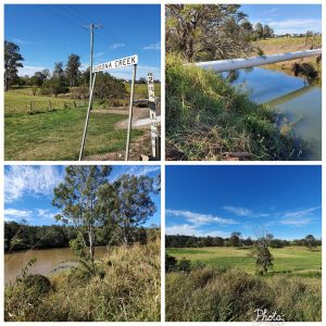
- The cattle station for sheep and cattle breeding at Redbank had three huts for the military, overseer and the convicts. It was situated 53 km upstream Brisbane River, and was named by Major Lockyer in 1825 after the red soil in the riverbank. In 1832 the outstation was established at Redbank on the Goodna Creek . It was most likely extended from the old convict road from Brisbane to Ipswich (now Brisbane Road) further south to what is now Bellbird Park. WE get an idea of its size as 200 hectares of government land (most likely the former station)were later gazetted for a Riffle Range, but was never used for it.
- Cowper’s Plains (later Coopers Plains) was probably named by Patrick Logan after Dr Henry Cowper, Assistant Surgeon-in-Charge at the Moreton Bay Penal Settlement from 1823 to 1832. A convict settlement was established at Cowper’s Plains in 1828, at the crossing of the convict road from Brisbane to Ipswich and the ‘squatters highway’ from the Darling Downs to Cleveland (where they planned to have a port). At the outstation there was one hut for the military and one for the convicts. It was most likely around the area where there is now a bridge in Musgrave Road over the Stable Swamp Creek.
- Logan, named after the Commandant of the Moreton Bay Penal Settlement, Captain Patrick Logan. He discovered the Logan River and noted the river was well suited to large-vessel traffic and was a first-class avenue to access the high-quality arable land along its banks. A sheep and cattle station was most likely established here as it is mentioned that after the end of the convict settlement the land was taken over by early settlers.
For most of the convict period however, there was a lack of convicts to herd the ever increasing number of sheep and cattle. By the mid 1830’s Commandant Fyans reported that there were 500 ‘beautiful’ oxen. 10,000 sheep at Limestone alone and 2,500 pigs in herds including one on Peel Island and one in town. Milk cows were also herded in town. The pastoralists started to complain about the extensive government herds, as it provided unfair competition with their businesses. The Government decided to start selling of its stock in 1843, however it was until 1848 that full disposal finally happened. It had been a very lucrative business for the Government in NSW.