The economic development of the new colony depended very much on the export – mainly of wool – via the river. Boats and shipping services were the earliest forms of commercial transport along the Brisbane River.
Moreton Bay was both a blessing and a curse. It provides access to the world, without the Bay there would not have been a Brisbane. However, a major problem for ships coming to Brisbane were the many shifting sands banks in Moreton with a major sandbar right in front of the mouth of the river. The depth was only 1.5 meters at low tide and 4 meters at high tide, too low for larger coastal and deep-sea vessels. Only flat bottom boats could enter the river. Others moored at Stradbroke Island and cargo and passengers were than loaded in smaller boats. Plans for the removal of the sandbar date from 1850. While some dredging might have started in 1855, lack of funds did not see this happening in any proper way until 1862. The work started at the river mouth, cutting a channel through the bar, enabling ships to berth at Lytton. It has been an ongoing job ever since that time.
In 1848 the harbour master was moved from Amity Point to Moreton Island. However demands for a telegraph signal station were ignored, the call for a lighthouse however was finally answered in 1857.
South Brisbane
South Bank from the start of the post-penal settlement became the easiest place for produce to be shipped as it came in from agriculture areas such as Darling Downs and Upper Brisbane River. It had the largest wool stores and most of the wharves.
The first commercial ‘wharf’ in South Brisbane was the McIntyre Tree made of logs with ships being tied to the tree.
The Hunter River Steam Navigation (HRSN) Company, established in Newcastle 1839, had started a regular service between Newcastle and Sydney and was also shipping to Brisbane, using the infamous tree wharf. The company tried to come to an arrangement with McIntyre to build a proper wharf at here. The HRNS had indicated it would lease river frontage and build South Brisbane’s first commercial wharf together with a store and a woolshed. With that money in the bag, the Government set aside the river frontage between Russell (where the ferry crossing was) and Melbourne Street for wharves, including a public wharf. The decision to build a new and modern wharf here would have been a boon for South Brisbane as that meant that this would be the main port for the supply of goods that arrived from the Darling Downs. and saw also the wharves, like the roads and the administrative system of the emerging town and state becoming highly political issues. The stubborn and greedy McIntyre did not want to come to the party. In 1859 the company moved away from the McIntyre Tree site and built there new wharf on the North Brisbane side of the river, this was a major setback for the developments South Brisbane as an important business hub.
Other wharves followed suit. Hockings Warf was erected next to the HRSN wharf, a bit further to the west. It was licenced as a sufferance wharf and was used among others by the general merchants Rundle, Dangar and Richards, who leased the store facilities at the wharf. Peterson’s Wharf was also situated in South Bank, it had direct access to Stanley Quay.
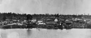
Russell Street at the left winding up the hill. South Brisbane Presbyterian Church at the centre right was erected in 1850. Hockings Wharf can be seen immdiately in front of the church, with a pit sawmill behind. Source: John Oxley Library, State Library of Queensland.
Kangaroo Point
In the meantime – in 1844 – the budding settlement of Kangaroo Point started to build a wharf at the point . It also build a road straight through the point to the old convict road between Brisbane and Ipswich/Darling Downs. Kangaroo Point developed as an industry centre, be at a small scale. This all meant that it had now become a serious competition to South Brisbane.
Having said that the old convict road was not at all equipped for the increased traffic and this in turn stimulated the river trade between Brisbane and Ipswich. However, river transport was more expensive so there was always the cry for a better road.
North Brisbane
While there was the Government Wharf at the penal settlement opposite the Commissariat Store, this was the only public wharf in town and it was not a good spot for goods coming from the Darling Downs, furthermore it had fallen into disrepair.
This started to change when 1851, Customs House and customs wharf were built on the northern site of the river at Petrie Bight. A Bond Store was added to the wharf. In 1854 the government established a shipping office and appointed John Ferriter as shipping master.However, the South Brisbane Wharf owners’ interests were enhanced with the new and better Coach Road to Ipswich in the 1860s. New wharves started to emerge next to those of the HRNS.
In March 1851, the HRSN company was reformed as the Australasian Steam Navigation Company (ASN). Following the decision to build the Customs House in North Sydney the company acquired land here but it did not construct wharves until 1859. The company’s first wharf was erected on the new site followed by a second wharf near Eagle Street in 1861. Adjacent to the initial wharf the company’s Brisbane’s head office, Nadlam House in Mary Street was built in 1864. The building was extended in the late 1870s.
In 1887, ASN amalgamated with the Queensland Steam Shipping Company to form the Australasian United Steam Navigation Company and two years later Nadlam House was substantially rebuilt. The company existed till 1961.
Conflicting interests
The decision to built Customs House in North Brisbane was a major setback for the political cause of the squatters who wanted Cleveland or Ipswich to become the key port for the emerging new colony.Until that time the Government had still been looking at Cleveland a potentially becoming the major port for Brisbane. This now did make private investments rather risky, at the same it lifted Brisbane’s chances to maintain its function as the major port city.The squatters from the start preferred Cleveland as the port as it was directly on the bay and would avoid double handling. This battle lasted for two decades but the mudflats made it not suitable as a port city.
In the early years of the settlement there was no indication which town would become the main town of the colony. The squatters wanted this Ipswich to be and boycotted as much as possible Brisbane being developed in the major town. They even favoured Cleveland (Emu Point) as a port on Moreton Bay above Brisbane. To assist the squatters with the double handling of goods during transport Chambers and Petrie built a store and wharf at Red Bank in 1842, but also this one was boycotted by the squatters. Instead, they built a road (track) from Ipswich to Emu Point as well as a wool store and wharf.
After Separation
By the time, the political issue regarding the capital city was settled, and Brisbane was chosen as the main city and the main port. Soon after that major wharf building now also started to emerge on the northern site of the river.
Petty jalousies and selfish interests remained however a key issues, now the capital city was resolved there was a clear ‘them and us’ divide between South Brisbane, Kangaroo Point and North Brisbane. Sufferance wharves was one such issue. These are places appointed by order under the hands of the Commissioners of Customs and Excise for the lading and unlading of goods liable to Customs duties. They were initially only in South Bank and ongoing disputes continued as those in North Brisbane also needed one. Individual complaints about some merchants and government officials were send to Sydney over the heads of the local organisations and authorities. These situations didn’t assist in the attempt to create a new state independent from NSW. It was still very much an individualistically-based community, with little cohesion to look at the broader issues.
A major problem for ships traveling up and down to Ipswich was Seventeen Mile Rocks, this splits the river in two, with hazardous rocks in both channels. They have been trying to blast rock ways as early as in 1862, 1865 and 1866 but only received the desired outcome in 1965, by that time Brisbane as a river port was already coming to an end.
The Queensland Pilot Board and Steam Navigation Board was established in 1853 they controlled the shipping and the custom procedures. This was followed in 1862 with appointment of a Marine Board and first Colonial Port master. Three years later the Marine Board was elevated to an official Government Department (The Department of Harbors and Rivers).
Shipyard from Taylor Winship at the south side of where now the William Jolly Bridge is.
The docks at South Brisbane were easier to access at that stretch of the river. The commercial success of the Eagle Street pier came in a later era, by which time the South Brisbane docks were riding on the success of coal exports. Other Brisbane Southside suburbs were also able to make important use of the river. Bulimba became the centre for shipbuilding. The launch of a vehicular steam ferry to Bulimba in 1886, marked another north-south access, one away from the inner-city traffic. Mowbray Park in East Brisbane and Orleigh Park in West End are the best examples of the city’s riverside reserves, combining recreation and public transport needs. The West End to Toowong ferry began operating in 1876. Public baths (swimming areas) were established on the banks of the river, for example at Dutton Park near the bottom of the South Brisbane cemetery.
In its heydays the wharves along Brisbane River stretched out over 20 kms.