The River
In 1825 Henry Miller explored the site what would first would become the Moreton Bay Penal Settlement and later Brisbane Town. The river was of course the prime transport corridor., it meanders through the area and Miller saw the potential of this both for the convict settlement but even more so for the future city that eventually would sprout up here. He also understood the potential of flooding as all buildings in the settlement were built on higher grounds.
We now know that river is approximately 40 million years old and that its current bed was established 10 million years ago. The source is on the Great Dividing Range, east of Kingaroy and from here it travels for just over 300 kms to Moreton Bay. Together with its tributaries the Stanley and Bremer Rivers as well as 22 creeks it has a catchment area of more than 13,500 square kms. The local Aboriginals had given it the name of Maiwar.
Miller also understood the potential of flooding as all buildings in the convict settlement were built on higher grounds (which is still visible in Queen and William Streets. Ever since that time the city has failed to understand the river and started to massively extend their build up areas in the floodplains of the river. The devastation ever since that time has been enormous but never has the core problem, development of the floodplains been addressed instead they have been trying to tame the river though dams.
As early as 1866 Andrew Petrie complained about the poor planning of Brisbane. He regretted that all the waterfront land was developed and locked into private hands and argued that instead it should have been made public land. However the early surveyors had by that time already subdivided the land on the edge of the river in order to maximise the development of the floodplains, a practice that has continued into this time.
Wheat Creek
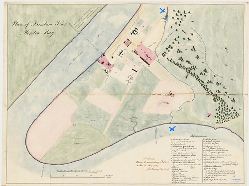
Miller also located fresh water at the lagoons in the area now occupied by the Rome Street rail yards. The area here was rather flat and flanked by some low laying hills and the escarpment. Creeks from these hills (both from Spring Hill and Petrie Tce) came down to swampy area where they combined in a range of ponds and from here the creek went via what is now the CBD to the river.
One of the springs flows under the Parkland Boulevard Apartments and is visible through a grid in the lower basement.
Under the direction of Captain Patrick Logan an earth dam was built across the creek between Roma and Little Roma streets in the late 1820s (approximately near the western wall of the present Magistrates’ Court building). Water was carried from the dam through a pipeline made of 15cm wide hollow hardwood logs to the soldier’s barracks near George and Queens Streets. A California pump was put in a shed with a shingle roof which was bad for drinking water. After the convict era water was sold for 1 shilling per gallon, very expensive. The water was of an extreme poor quality which resulted in diseases and even death, especially among children.
In 1827, a small wooden bridge was constructed over the creek at what is now the corner of Albert and Adelaide Street (behind the former North Brisbane Hotel). This bridge was replaced in 1861. From here there was access from the convict settlement to the reservoir, the upper parts of the creek, which were earmarked for agriculture land and the hills where they planned to build a windmill. The road from the settlement was extended from the bridge to the mill on top of the hill of what is now Wickham Terrace.
The old Wheat Creek also sometimes referred to as Big Creek runs from Upper Roma Street to the River. It is still traceable thanks to gutter markers. The first marker I could find was in Upper Roma Street (near the backpackers places) from here: McCormack Place (close to the old burial ground), Roma Street (at the top only on the northern side), at the station on both sides of the road, George Street – than under the Supreme Court back into Roma Street, into Albert Street, here it goes under King George Sq, than a sharp turn to the left into Adelaide Street and a similar turn to the right into Creek Street (last two markers that I could find here), from here I know it goes under Riverside Centre and flows into the River.

The creek became known as Wheat Creek. The name of the creek indicates that the flats next to it was used for agriculture (maize – the humid climate in Brisbane was not suited for wheat). The name Creek Street in the City reminds us of this creek. It was here that in 1835 the 2nd bridge was build on what is now the corner of Queen and Creek Street. The creek joined the Brisbane River where currently the River Quarter is situated. The name ‘street’ is a bit of a misnomer as at that time it was just a mud bank along the creek.
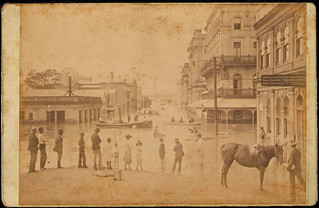
They started to plan for a proper drainage system as soon as more and more immigrants started to arrive. Despite drawn up plans there was no money available for such a plan, the State Government of NSW was not willing to fund it. After independence this started to change, interrupted by a severe economic downturn. In the end during the 1870s the creek was piped in and slowly the CBD area became more livable. Parts of these drains still exist under the CBD.

They also built a pipe from the reservoir to North Quay, through here some of these watercourses from Spring Hill and Green Hills are now drained through this pipe into the river. The rest of the creek follows the creek through the CBD (now in pipes) to the original outlet on other side of the river.
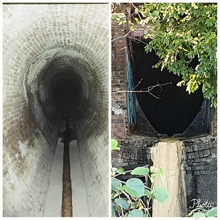
At the spot where now the City Hall stands was another swampy area. It remained council land but was leased in 1854 to Thomas Alford who set up the Brisbane Horse Repository , this included stables and yards. People who travelled into Brisbane could ‘park’ their horse here. Later it was leased to to Cobb & Co who operated a livery from here. The swampy are became known as the horse pond. In the 1930s City Hall was build on this swamp.
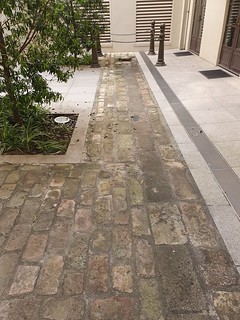
Cost were estimated at A£300,000, however in the end it costed just under A£1 million. However the horse pond would haunt the building. Serious problems were identified with the building, including subsidence, concrete cancer, a lack of reinforcing in the concrete and old wiring. An urgent restoration was launched in 2010, it was completed three years later at the costs of A$210 million.
Close to where the creek flowed into the river was another bridge. Tom Petrie indicated that it would roughly be opposite the warehouse of Campbell & Son (since demolished at that stage occupying 12-20 Creek Street) which was at the end of the garden of the Petrie’s. The bridge was simply three long logs spanning the creek. However, it must have been rather substantial as it crossed a large flat bank as well. This spot provided a good hiding place where the crow-minder of the corn fields could cook his own maize meal. The Petrie brothers chipped in some tea, flour and sugar. The crow-minder at that time called Andy made doughboys which they all enjoyed.
In 1849 the bridge was also the site of a tragic accident, the twenty-two year old Walter Petrie, Andrew Petrie 2nd son, slipped on the beams of the bridge, hit his head became unconsciously and drowned in the creek. Tragically in 1857 another Walter Petrie, this time the 22 months old son of John Petrie, Andrews oldest son, drowned in the creek a bit further up stream near Queen Street.

The mouth of the creek was a rather broad ‘delta’ with mangroves. Here the convicts had built a construction to catch crabs and fish. Beams on both side in the mud provided the access in the middle a block and tackle construction with in the river a large basket. They used the ebb and flow of the tide to catch the fish. In order to not frighten the fish they only used the trap two or three times a week. In Tom’s time the basket maker was Bribie. He was on a short sentence and had access to a boat to collect cane for his baskets. Tom mentioned that Bribie Island had been named after him.

A second bridge was built in 1828 over the creek, at the back of the Convict Barracks, roughly where Albert Street and Adelaide intersect
Little Creek
Another low laying area known as Frog’s Hollow bordered what is now the City Botanical Garden, this was another – the main – farming area of the settlement, known as the Government’s Garden. There was also running a creek through this area (Little Creek) and it entered the river at the end of what is now Alice Street. There was also a small plank bridge here just before the creek went into the river. The creek drained the swampy area known as Frog’s Hollow. It basically was the area now enclosed by Elizabeth, Alice, George and Edward Street.
The convict buildings were all established on the ridges. When the free settlement opened up people started to fill in other areas in the settlement the creeks and the various hollows and ponds became flood hazards.
A drainage system was started in 1860 using this creek. The first parts were from Elizabeth Street to Albert Street and from here to Margret Street were it emptied in the creek.
Boundary Creek
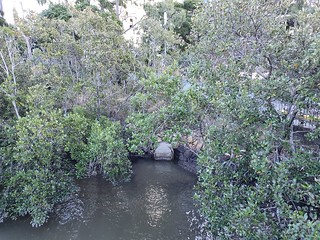
The city boundary was revised in 1856, expanding it from Petrie Bight (Eagle Terrace) out to Boundary Street (now Boomerang Street) in Milton. Boundary Creek marked the extension of the city’s new boundary. In 1857, three bridges were build in this area. The major one was the bridge over Moggill Road/River Road/Coronation Drive where the creek flowed into the river. The creek had several local names including Bennett’s Creek. The creek was an ongoing problem for the new settlers here as it was in need of ongoing repairs, especially after heavy rain when parts kept be washing away. The bridge got that unofficial name after E.J. Bennett who had settled into the locality in the 1860s. He was the Chief Draftsman of the Surveyor General’s Department. Before that it was known as Milton Bridge and Boundary Bridge.
There were several more creeks in or close to the centre of town: West Creek in Milton and Norman Creek in southern Brisbane.
Cabbage Tree Creek was another early creek that received a bridge in 1853.
The Breakfast creek history is mentioned in the Eagle Farm chapter.